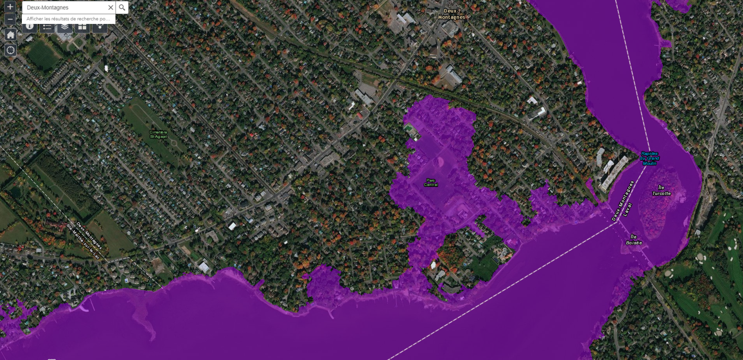
Deux-Montagnes, July 15, 2019 – Following the public assembly held on July 4th by the Quebec government, concerning the draft order to declare a special planning zone (SPZ), the ministère des Affaires municipales et de l’Habitation (MAMH) has published today an adjusted mapping of the flooded territories following the floods of 2017 and 2019.
The new version of the map can be viewed online at https://www.cehq.gouv.qc.ca/zones-inond/zone-intervention-speciale.htm
The mayor of Deux-Montagnes, Denis Martin, believes that the new map effectively takes into account the known data and more accurately reflects the reality. “I am reassured by the new boundaries of the SPZ, which are similar to existing maps made with the assistance of hydrologists and experts. Nevertheless, I still deplore the immense stress and worries that the government unnecessarily caused to the hundreds of citizens wrongly affected by the first mapping unveiled last June ” he said.
Do you have any concerns related to the new boundaries of the SPZ?
If inaccuracies in the delimitation of the flooded territory remain, the municipalities can submit their requests to the MAMH until August 19. The citizens of Deux-Montagnes wishing to issue their comments are invited to do so by contacting the City of Deux-Montagnes by e-mail at urbanisme@ville.deux-montagnes.qc.ca, or by contacting the Urban Planning Department by phone at 450-473- 4833.
About the SPZ
By this draft order, the government aims to promote better management of flood zones and, in particular, to impose a moratorium on the construction and reconstruction of buildings located on the SPZ territory, until the development of a new normative framework by the Quebec government.
To learn more and to consult all the relevant documentation, visit the MAMH website: https://www.mamh.gouv.qc.ca/ministere/inondations-printanieres-2019-zone-dintervention-speciale/